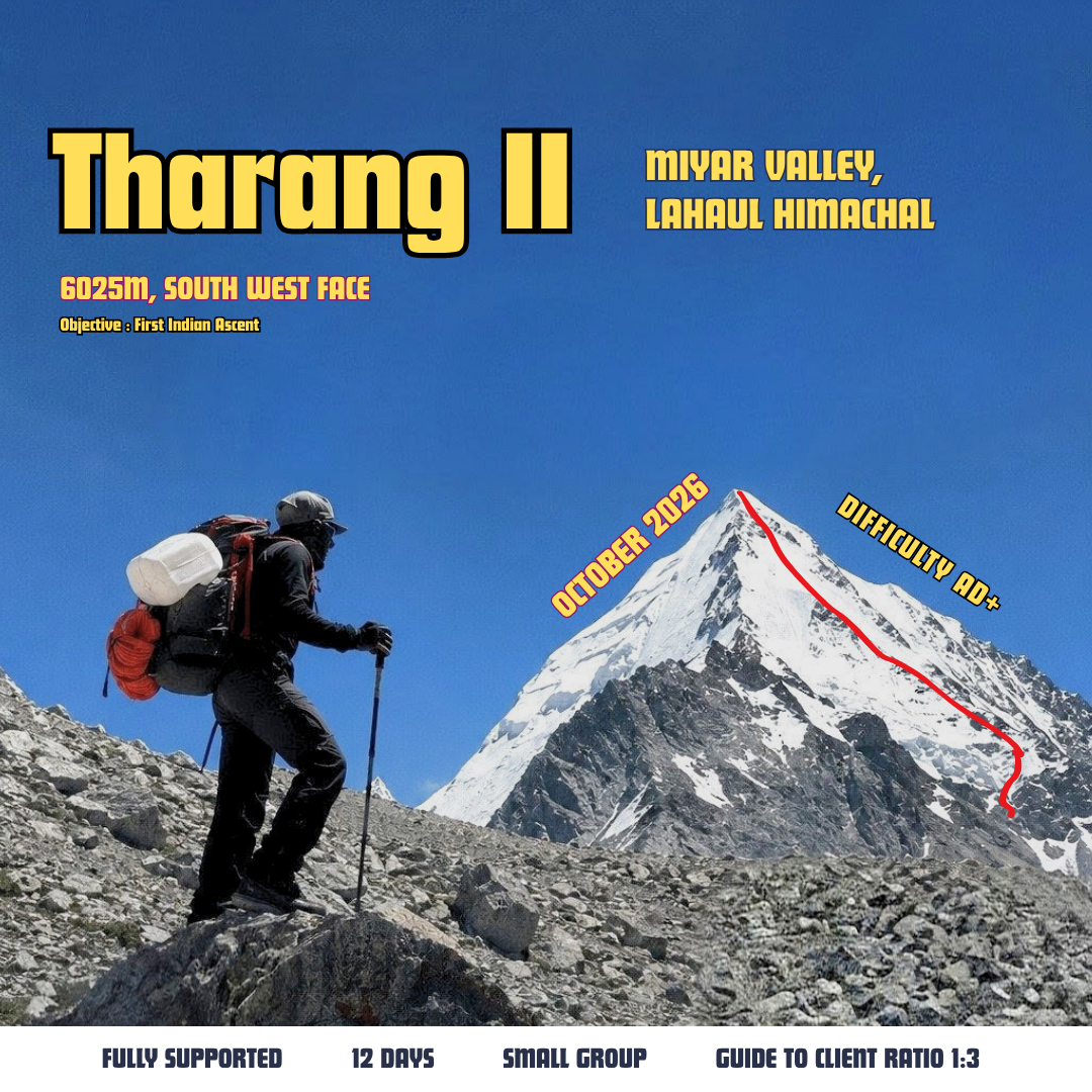
THARANG II 6,021M
Tharang II Southwest Face Expedition
Tharang II—also known as Shailaputri—is a 6,021-metre Himalayan summit above the Uldhampu Valley in Himachal Pradesh. This 14-day, Keylong-to-Keylong expedition approaches the mountain through Khanjer before establishing Base Camp, Camp 1, Camp 2 and a 5,270-metre summit camp.
The southwest route combines a remote Himalayan approach with progressive acclimatization, load ferries and technical climbing at altitude. Depending on current mountain conditions, participants should be prepared for glacier travel, scree, loose rock, steep snow, roped climbing and rappelling.
The Southwest Face
A 2012 British expedition referred to the peak as Tharang II. Charlie French and Anette Kinde made the first documented ascent in October 2016 and named the summit Shailaputri.
Their southwest-face route crossed the glacier and steep scree before following ramps to a prominent spur. Above approximately 5,800 metres, they climbed around 250 metres of 50–60° snow, using ice-screw and rock protection where possible. They graded the climb AD and descended by reversing the spur and completing three long rappels.
The historical account also identifies loose rock and rockfall as significant hazards. It provides useful route context, but the exact line and conditions encountered during this expedition may differ.
Read the American Alpine Journal route report
Expedition Style
The itinerary uses staged camps and load ferries to support acclimatization and move equipment progressively higher. Two buffer days are included, but they may be used at any stage in response to weather, route conditions, team health or operational delays.
Guided Alpine Style: A smaller, self-reliant team format intended for experienced climbers. Participants take greater responsibility for personal equipment and expedition movement.
Fully Supported Expedition: A more comprehensive expedition format with additional logistical and camp support.
View full detailsExpedition Itinerary
Day 1: Keylong to Base Camp
Drive from Keylong to Khanjer and begin the approach trek to Base Camp. On arrival, establish camp and complete an initial expedition briefing.
Day 2: Acclimatization at Base Camp
Spend the day acclimatizing, organizing equipment and preparing loads for the higher camps.
Day 3: Load Ferry to Camp 1 — 4,260 m
Carry equipment and supplies to Camp 1. Establish a load cache before descending to Base Camp.
Day 4: Move to Camp 1 — 4,260 m
Leave Base Camp and move up to Camp 1. Settle into camp and prepare for the next stage of the ascent.
Day 5: Load Ferry to Camp 2 — 4,820 m
Carry equipment and supplies from Camp 1 to Camp 2. Establish a load cache and return to Camp 1.
Day 6: Move to Camp 2 — 4,820 m
Ascend to Camp 2 and establish the team at 4,820 metres. Continue acclimatization and assess conditions higher on the mountain.
Day 7: Load Ferry to Summit Camp — 5,270 m
Carry technical equipment, food and essential supplies to Summit Camp. Establish the high camp before returning to Camp 2.
Day 8: Move to Summit Camp — 5,270 m
Move into Summit Camp and make final preparations for the summit attempt. The guide will assess the weather, route and condition of the team.
Day 9: Summit Attempt — Tharang II, 6,021 m
Begin the summit push via the southwest route. The attempt is subject to weather, snow and route conditions, participant readiness and the expedition guide’s judgment. Descend to the safest appropriate camp after the attempt.
Day 10: Descend to Camp 1
Descend from the upper mountain to Camp 1. Recover equipment and loads where conditions permit.
Day 11: Return to Base Camp
Continue the descent to Base Camp. Reunite with the support team and begin consolidating expedition equipment.
Day 12: Return to Keylong
Trek from Base Camp to Khanjer and transfer by vehicle to Keylong, where the scheduled expedition concludes.
Day 13: Contingency Day
Reserved for weather delays, additional acclimatization, changing route conditions or operational requirements.
Day 14: Contingency Day
A second buffer day for summit scheduling, descent or unforeseen delays. If unused, the expedition concludes in Keylong.
Key Stats
Expedition Itinerary
Day 1: Keylong to Base Camp
Drive from Keylong to Khanjer and begin the approach trek to Base Camp. On arrival, establish camp and complete an initial expedition briefing.
Day 2: Acclimatization at Base Camp
Spend the day acclimatizing, organizing equipment and preparing loads for the higher camps.
Day 3: Load Ferry to Camp 1 — 4,260 m
Carry equipment and supplies to Camp 1. Establish a load cache before descending to Base Camp.
Day 4: Move to Camp 1 — 4,260 m
Leave Base Camp and move up to Camp 1. Settle into camp and prepare for the next stage of the ascent.
Day 5: Load Ferry to Camp 2 — 4,820 m
Carry equipment and supplies from Camp 1 to Camp 2. Establish a load cache and return to Camp 1.
Day 6: Move to Camp 2 — 4,820 m
Ascend to Camp 2 and establish the team at 4,820 metres. Continue acclimatization and assess conditions higher on the mountain.
Day 7: Load Ferry to Summit Camp — 5,270 m
Carry technical equipment, food and essential supplies to Summit Camp. Establish the high camp before returning to Camp 2.
Day 8: Move to Summit Camp — 5,270 m
Move into Summit Camp and make final preparations for the summit attempt. The guide will assess the weather, route and condition of the team.
Day 9: Summit Attempt — Tharang II, 6,021 m
Begin the summit push via the southwest route. The attempt is subject to weather, snow and route conditions, participant readiness and the expedition guide’s judgment. Descend to the safest appropriate camp after the attempt.
Day 10: Descend to Camp 1
Descend from the upper mountain to Camp 1. Recover equipment and loads where conditions permit.
Day 11: Return to Base Camp
Continue the descent to Base Camp. Reunite with the support team and begin consolidating expedition equipment.
Day 12: Return to Keylong
Trek from Base Camp to Khanjer and transfer by vehicle to Keylong, where the scheduled expedition concludes.
Day 13: Contingency Day
Reserved for weather delays, additional acclimatization, changing route conditions or operational requirements.
Day 14: Contingency Day
A second buffer day for summit scheduling, descent or unforeseen delays. If unused, the expedition concludes in Keylong.
Group Size
Small expedition teams allow closer guide coordination and flexible movement between camps. Final movement and summit decisions remain subject to weather, route conditions, team fitness, and guide judgment.
Inclusions
Guest House Accommodation: Stay in Keylong or another required location during the expedition.
Transfers: All vehicle transfers from Keylong to Keylong, as specified in the itinerary.
Meals: All meals during the expedition.
Expedition Guide: An expert certified guide with extensive knowledge of mountaineering routes and peaks.
Support Staff: A specialized cook, porters and other required support staff.
Expedition Accommodation: Tents on a twin- or triple-sharing basis.
Camping Gear: Sleeping bag, carry mattress and other required camping equipment.
Technical Equipment: Group and personal technical equipment as specified, including static and dynamic ropes, carabiners, slings, ice axe, gaiters, microspikes or crampons, and related equipment.
Camp Facilities: Kitchen tent and toilet tent, as required.
Permits and Fees: Required permit fees, camping charges and forest levies.
Medical Kit: Basic medical and first-aid kit.
Exclusive Discount: Participants receive a discount at Skimo.in.
Exclusions
Travel to and from Keylong.
Personal clothing, footwear and equipment not specifically included.
Travel, medical, evacuation and rescue insurance.
Personal expenses and gratuities.
Additional expenses caused by weather, road closures, evacuation, delays or itinerary changes.
Anything not specifically listed under Inclusions.
Objective Hazards and Safety
This is a high-altitude mountaineering expedition with inherent risks. Possible hazards include altitude illness, crevasses, steep snow, loose rock, rockfall, cold, wind, changing weather and complex descent terrain.
Summit success cannot be guaranteed. The expedition guide may modify the route, camps, itinerary or summit plan when required for safety. All summit and movement decisions remain subject to weather, mountain conditions, team readiness and guide judgment.